Richmond Valley Flood Study 2023
In 2021 Council commenced the Richmond Valley Flood Study with financial and technical assistance provided by the Department of Planning and Environment under the Floodplain Management Program. This study has now been adopted by Council.
NSW Flood Management Framework
Flooding in NSW is managed in accordance with the NSW Government’s Flood Prone Land Policy (the Policy).
The NSW Government’s Floodplain Development Manual (DIPNR, 2005) was replaced on 30 June 2023 with the Flood Risk Management Manual: The policy and manual for the management of flood liable land (DPE, 2023).
Both manuals support the Policy by defining the responsibilities, roles, and processes for the management of flood prone land in NSW.
This includes the development and implementation of local flood studies and floodplain risk management studies and plans to define and manage flood risk.
These are prepared through a staged approach which is defined by the flood risk management process shown below. The Richmond Valley Flood Study (the Study) represents Stages 1 and 2 of the process which remains fundamentally unchanged in the new manual.
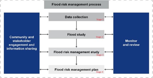
Stages in the NSW Flood risk management process (Adapted from Flood Risk Management Manual, 2023)
The Flood Study
BMT Commercial Australia Pty Ltd was commissioned in early 2021 to prepare a new flood model and study for the Richmond Valley LGA’s floodplains.
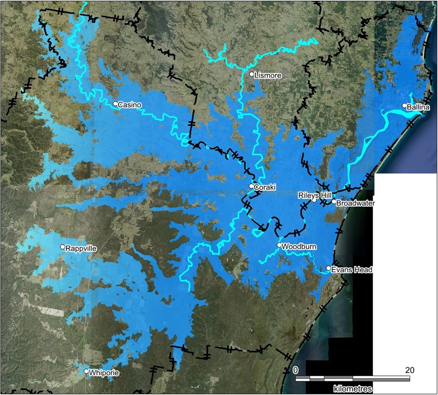
The Flood Study covers the main rivers and creeks within the Richmond Valley Local Government Area (LGA) from upstream of Casino to downstream of Broadwater and as far as Ballina, including Coraki, Woodburn, Rileys Hill, and Evans Head, as well up the Bungawalbin Creek including Rappville and Whiporie, and up the Wilsons River as far as East Gundurimba.
The scope of the project was:
- replace a number of historic flood studies with a single, consistent, up-to-date, and higher-resolution flood model,
- expand modelling to a larger part of the LGA’s floodplains (about 86% of the LGA’s floodplain has now been modelled, which is up from 52% coverage within existing studies),
- incorporate Climate Change (CC) as well as Australian Rainfall and Runoff 2019 (AR&R2019) standards into the modelling,
- incorporate significant floodplain terrain modifications into the model, such as the inclusion of the Pacific Motorway upgrade and
- calibrate to several historic flood events.
This scope of the project was further expanded in 2022 to incorporate data from the 2022 floods into the model’s calibration and Study’s flood frequency analysis.
The Richmond Valley Flood Study 2023 was adopted at the Ordinary Meeting of Council held on 19 September 2023 and will assist with managing the community’s risk from flooding.
This new flood study and flood model has replaced the following flood studies:
- Casino Flood Study (1999),
- Richmond River Flood Study (2010), and
- Evans River Flood Study (2014).
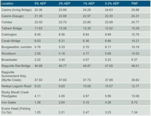
The Flood Study has been calibrated against historic flood events for January 2008, May 2009, March/April 2017, and Feb/Mar 2022. This calibration exercise involved applying recorded rainfall data into the models and comparing modelled flood levels with actual recorded river gauge data and surveyed debris marks. The table below provides the new design flood levels (in metres above the Australian Height Datum) for key river gauges with the study area.
Climate Change Scenario 3 – Update flood modelling
The Richmond Valley Flood Study has included climate change simulations for the 2%AEP (50year AEP), 1%AEP (100yr AEP), and the 0.2%AEP (500year AEP).
At the Council meeting of 15 June 2010, Council adopted Climate Change Scenario 3 to apply to flood modelling. This included an increase of:
+ 900mm for sea level rise, and
+ 10 percent increase in rainfall intensity.
The new flood levels with Climate Change 3 form the basis for future development in accordance with Council’s Floodplain Risk Management Plans, and clause 5.21 Flood Planning within the Richmond Valley Local Environmental Plan 2012.
New flood mapping, minimum habitable floor levels and hazard categories in accordance with Council’s adopted Floodplain Risk Management Plans are also available.
Further information
Council will receive a package of flood-related documentation and maps from completing the Study. This will be updated below as it becomes available.
- Richmond Valley Flood Study 2023 – Report
- Richmond Valley Flood Study 2023 – Volume 2 – Mapping
- Casino Flood Planning Matrix – Rural
- Casino Flood Planning Matrix – Other
- Casino House Survey – November 2006 Update
- Mid-Richmond Flood Planning Matrix – Urban
- Mid-Richmond Flood Planning Matrix – Rural
- Mid-Richmond Flood Planning Matrix – Other
- Mid-Richmond House Survey – November 2006 Update